It looks like a portal torn open in the sky: a twisting column of flame clawing upward, devouring air with a freight-train roar. Photographs of so-called firenadoes feel surreal, but the physics behind them is disarmingly real—and increasingly relevant as fire seasons intensify around the world.
What appears otherworldly is, in fact, a stark lesson in how heat, wind, and terrain can conspire to turn a wildfire into a force that makes its own weather.
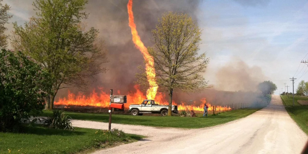
What you’re seeing when fire begins to spin
A firenado is shorthand for a spectrum of spinning fire behavior, from small fire whirls that dance over brush to rare, tornado-strength vortices rooted in a fire’s towering smoke plume. In both cases, intense heat from the flames creates a powerful updraft. Air rushes in at the base, begins to rotate, and the column tightens—just like an ice skater pulling in their arms to spin faster.
These columns can loft flaming embers thousands of feet and hurl debris in every direction. The hottest ones tear bark from trees, flip vehicles, and splinter power poles. Even at modest scale, a fire whirl can leap containment lines and turn an orderly frontline into chaos within seconds.
The rare leap from whirl to true tornado
Most spinning columns on a fire are transient whirls: dramatic but short-lived and typically tens of yards wide. A true fire tornado is rarer and far more dangerous. It is a rotating vortex that extends upward into a deep, smoke-fed cloud and produces winds comparable to severe thunderstorms. In July 2018, the Carr Fire near Redding, California, generated such a vortex, with peak winds of more than 140 miles per hour and damage consistent with an EF-3 tornado on the Enhanced Fujita scale. The rotating column carved a path through neighborhoods, uprooted steel transmission towers, and killed a firefighter.
What makes the difference? Scale and structure. When a fire’s plume grows tall enough to form a pyrocumulus cloud—sometimes maturing into a storm-like pyrocumulonimbus—the system can organize like a supercell, tilting and stretching ambient wind shear into a tight spin. That’s when a convecting fire can transition from turbulent whirls to a coherent, tornadic vortex anchored to the fire itself.
How a firenado forms: fuel, heat, and spin
Fuel, heat, and topography
Wildfires pull their energy from dry fuels and hot, unstable air. Steep slopes and canyons accelerate uphill winds, funneling inflow toward the flames. When that air is forced into a narrow corridor—between ridgelines, for example—it can begin to rotate, especially if nearby terrain or shifting gusts add a nudge of spin. The rising column tightens that spin dramatically, transforming ragged flame fronts into a rotating chimney.
Wind shear and the towering plume
Above the fire, the plume can climb several miles. If winds change direction or speed with height—a condition known as wind shear—the updraft can tilt and intensify rotation. The result is a vertical, rotating column that behaves like the updraft of a thunderstorm. In extreme cases, the cloud cap glaciates into pyrocumulonimbus, producing lightning, outflow winds, and further volatility—feedbacks that can multiply risk for crews and communities downwind.
Why we may be seeing more of them
Fire behavior experts stress that firenadoes remain rare compared with the countless blazes that burn each year. Yet the backdrop is changing. Longer, hotter, and drier fire seasons in many regions are fueling larger, more intense wildfires—exactly the kind that build towering plumes and erratic winds. As heatwaves grow more severe and landscapes shift toward flammable conditions, the odds of plume-dominated fires rise, stacking the deck for the kind of spinning extremes that once seemed almost mythical.
Recent fire seasons in Australia, the western United States, the Mediterranean, and parts of South America have shown how quickly conditions can escalate. During the 2019–2020 Australian bushfires, multiple pyrocumulonimbus events lofted smoke into the stratosphere and circled the globe—evidence of fire-generated weather on a planetary scale. While most of those storms did not produce tornadic vortices, the atmospheric ingredients for dangerous rotation were more present than in past decades.
The frontline reality for firefighters
For incident commanders, a spinning column is both a weather signal and a tactical alarm. It tells crews that the fire has transitioned from wind-driven to plume-dominated—when the blaze begins to dictate its own winds. Spot fires can leap a mile or more ahead. Access roads that looked safe can become deadly chutes if the vortex shifts. Even heavy equipment and engines are vulnerable to gusts strong enough to topple them or trap crews in radiant heat.
Operationally, that means anchoring lines early, widening safety zones, and elevating evacuation priorities. A plume that tilts and then straightens is a warning sign; so are sudden, blasting inflow winds into the fire’s base and the rapid growth of a cauliflower-like pyrocumulus cloud. In these moments, minutes count more than maps.
Reading the sky when smoke towers
For residents in fire country, situational awareness can save lives long before a formal order arrives. If a smoke column deepens from a flat haze into a towering stack, and winds at ground level begin streaming toward the blaze, conditions are escalating. A column that darkens and pulses—breathing in and out—signals powerful updrafts and the potential for erratic winds.
- Leave early if you are in a warning zone; waiting for visible flames is waiting too long.
- Know at least two evacuation routes and avoid canyons or ridgelines where winds can channel and accelerate.
- Keep vehicles fueled, essential documents ready, and masks available for smoke exposure.
- If trapped, seek wide, cleared areas or large, green fields—never a narrow roadway hemmed by brush.
What science is learning next
Researchers are racing to pin down the thresholds that tip a blaze into tornadic behavior. Mobile Doppler radars have scanned fire plumes, revealing bands of rotation and startling wind speeds within the smoke. High-resolution satellites now track heat signatures and plume height in near real time, helping forecasters anticipate dangerous transitions. The goal is to give incident teams and communities an earlier heads-up when a fire starts to build the architecture for a vortex.
The work is urgent but hopeful. Better data, combined with smarter land management—thinning overgrown forests, restoring cultural burns, hardening homes—can reduce the raw fuel that feeds the tallest plumes. While we can’t turn down a heatwave or stop a drought, we can lower the chances that a wildfire grows into a self-made storm.